Posts

Showing posts with the label NZHPT

Pa Sites at the Gateway to Manukau
Image
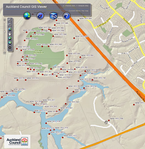
As you drive along Puhinui Road from the airport towards Papatoetoe and Manukau City Centre, you’ll pass some of Papatoetoe’s oldest historic places. These are pa sites that today guard this gateway to Manukau. The major site here is the Papatoetoe Pa (NZAA reference number: R11/59).  The pa was formed on a headland near the upper reaches of the Waokauri Creek, where it controlled the Papatoetoe portage. Papatoetoe Pa was protected on its landward side by a ditch and bank originally about 50 metres long. The pa was about 105 metres in length, 60 metres wide at its broadest point; reducing to 25 metres wide at its tip. Ref: Map showing the headland pa (R11/59), Cultural Heritage Iventory (CHI), Auckland Council GIS Viewer. Please note the data shown in the map provides a rough guide to the site only  The photo below looks down at a branch of the Waokauri Creek from the pa entrenchment. Ref: Footprints 01427, Papatoetoe Pa, 1948, photograph reproduced by courtesy of ...

Auckland's Supreme Court Building

Image
One of the grandest buildings in Auckland is the striking Supreme Courthouse on the corner of Waterloo Quadrant and Anzac Avenue. A Hstoric Place Category 1 listed building, it has been described by Heritage New Zealand as a 'powerful example of Gothic Revival architecture'. Ref: 4-2587, showing the corner of Queen St Victoria St West and ( from left) the Courthouse, Guardroom, stocks, gaol, gallows and bridge over the Ligar Canal, 1850s, Sir George Grey Special Collections Built in 1868, it was not the first courthouse to serve Auckland’s growing population. There were in fact two earlier buildings. In 1842, the first was constructed on the land bordered by Victoria, Elliott and Darby Streets. Besides the courthouse there was a gaol, gallows, exercise yard, and even stocks. From the outset, though, the site was condemned as sub standard. The New Zealand Southern Cross expressed its distaste in its June 8th 1852 issue, saying, 'It is really too bad to pen up a judge,...

International Day for Monuments & Sites and the Matakana Island school

Image
International Day for Monuments & Sites is a World Heritage Day that highlights and celebrates the different aspects of heritage. It is organised by the International Council on Monuments and Sites (ICOMOS). The day was celebrated on 18 April and the theme this year was ' The Heritage of Education '. This was something which the New Zealand Historic Places Trust (NZHPT) felt that the Matakana Island community in the Bay of Plenty had a lot to celebrate. Te Kotukutuku School House on the island is one of the few surviving pre 1900 Native school houses in NZ. The building has been recently registered as a Historic Place Category 1 and was built on land donated by local iwi. Ref: 4-448, Military Cemetery in Tauranga with Matakana Island (on left) and the Mount (right) in the background, 1860s, Sir George Grey Special Collections

Former Synagogue on Princes Street

Image
The first Hebrew congregation began worship in Auckland in 1843. Their first formal place of worship was located in Nathan & Joseph's Warehouse in Shortland Street. By 1853 the congregation had grown to 100 and worship was held in a small building in Emily Place. By the 1860s this building had become too small for the rapidly increasing Jewish population and funds were raised for the construction of a synagogue. In 1884, the Jewish Community purchased a section on the corner of Princes Street and Bowen Street. At that time the site was occupied by the former Albert Barracks Guard House, which overlooked a vegetable garden, which had formerly been used by soldiers. Ref: 1-W136, the Jewish Synagogue in 1900, Sir George Grey Special Collections

In the spotlight: Albert Park's band rotunda

Image
Strike up the band for Albert Park. The band stand was built in 1901 and is the oldest surviving band stand or rotunda in the Auckland region. It was designed by James Slater, who also planned the layout of Albert Park. One of most interesting features of the band stand is its onion-shaped, domed roof. It is made of sheet metal and topped by a pointed finial. Ref: 35-R134, Albert Park showing the band rotunda, 1910-1919, Sir George Grey Special Collections The band stand is a registered category II historic place under the Heritage New Zealand Pouhere Taonga Act 2014 . But it is just one of a number of structures, monuments, artworks, trees and gardens that make this the region’s finest Victorian public park. This is reflected in Albert Park’s category A status as a protected heritage place in the legacy Auckland City District Plan (Central Area Section) (see pp.4-6).

Esplanade Hotel

Image
The Esplanade Hotel is an imposing three storey plastered brick building. Its three-sided facade is aligned so that the Hotel entrance faces Victoria Road - Queens Parade junction. The hotel was built by the Great Northern Brewery Company Limited on the former site of Holmes Brothers 'Flagstaff Hotel', which had opened in August 1864. The old hotel was moved to an adjacent site in Queens Parade, so that the new hotel could be built. The old wooden building was used as a staff residence and boarding-house until it was demolished in 1938. Ref: D_GSV-0009, Esplanade Hotel, c. 1909, North Auckland Research Centre

The Waikato War

Image
Discover New Zealand's past by travelling in the path of the Waikato War 1863-1864 . Hamilton and Waikato Tourism have teamed up with the New Zealand Historic Places Trust (NZHPT) to create a interactive way for people to understand and 'experience' the Waikato War. As NZHPT archaeologist Nigel Prickett says, 'The best way of understanding what happened at these places is to go there". The website is split into historical content and driving tour information including further information about key sites. The driving tour includes 13 major historical sites to visit along the way from Highwic in Auckland to Alexandra Redoubt in Pirongia. Ref: 435-C545, Highwic, Sir George Grey Special Collections

Waikumete Cemetery

Image
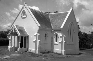
It’s dead good Waikumete Cemetery in Glen Eden is one of the most significant heritage places managed by Auckland Council. At 108 ha, it is New Zealand’s largest cemetery, the second largest in the southern hemisphere, and the resting place of over 60,000 people, some of whom played an important role in our history. The cemetery is just one of the many heritage assets owned or managed by Auckland Council on behalf of the community. Ref: JTD-12AA-02366-3, West Auckland Research Centre The cemetery opened in 1886 as a replacement for the overcrowded Symonds Street Cemetery. It was laid out by denomination and contains many historic graves and memorials of heritage significance. It includes a children’s section, soldiers’ cemetery, large lawn cemetery, Māori urupa, mass grave of over 1000 flu victims from 1918, and a memorial to the 1979 Mt. Erebus Air Disaster. The cemetery also contains a notable group of mausoleums and the historic Faith-in-the-Oaks Chapel (1886), Sexton’s ...

The beginnings of state housing in NZ

Image
This September celebrates the 75th anniversary of New Zealand’s first state house – number 12 Fife Lane, Mirimar, Wellington. The decision to build government-owned housing developed after the decline in construction following the Depression. That decline, combined with a belief that a decent home was a fundamental right of all Kiwis, set in motion the state housing project by the then Labour Government. Ref: 139 Greys Avenue state housing, 7-A1264, Sir George Grey Special Collections The opening of the first house in 1937 was attended by Prime Minister Michael Savage , along with hundreds of curious folk who traipsed through the brand new home for a look. The tenants were the family of council tram conductor, David McGregor, who had 'won' the home via a ballot system. That system did not, however, last. It was the subject of claims that it was unfair, and was later dropped in favour of a merit system.  Ref: PM Michael Savage, 1093-1, Sir George Grey Special Col...