Aerial photographs of Manukau from the Auckland Council Archives
It’s amazing the difference a few decades can make! These aerial photographs of Manukau City from the Auckland Council Archives show the previously open rural landscape to the more built-up area we know today. All showing the same exact location, it is fascinating to realise the growth of Manukau over 25 years, nearly 30 years ago.
 |
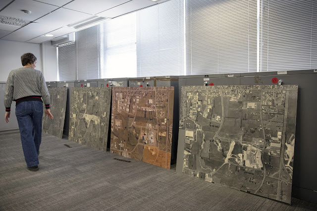
| Image: Photo taken by our Digital Archives Imaging Specialist Paul Chapman showing scale of these aerial photographs and other examples from the accession. |
The first image taken in 1972 and still in black and white lacks most of the recognisable landmarks, whereas the other two, taken in 1981 and 1994 are more recognisable with the inclusion of the Manukau Westfield mall and eventually Rainbows End. All of these images were printed on photographic paper pasted in chipboard and the scale here is 2 chains =1” meaning 40 meters = 1 inch approximately.
 |
| Image: Black-and-white aerial photograph of Manukau City Centre, 14 April 1972, AUC 2023 025 Item 7, Auckland Council Archives. |
If you look carefully, you can perceive slightly different shades of colour, especially in the 1981 image. This is because the full image is made up of a mosaic of smaller images (pieces cut and pasted together on the board); every printed piece does not react the same way to exposure to the environmental conditions, causing this variation in colour. These mosaics are incredibly accurate, the cut was made along a road or the edge of a building, in order to have the most homogenous result.
.jpg) |
| Image: Colour aerial photograph of Manukau City Centre, 10 June 1981, AUC 2023 052 Item 5, Auckland Council Archives. |
Originally framed, these photographs were likely on display to document Manukau’s development. Some of the Manukau City aerial photographs we gathered at Auckland Council Archives can be from oblique view and vertical view, starting from the 1970s, usually created as administrative records. Because of their large format, around 1.4 to 2 meters long, these records are quite unusual in our collection, and challenging to manage.
 |
| Image: Colour aerial photograph of Manukau City, 4 June 1994, AUC 2023 025 Item 1, Auckland Council Archives. |
In preparation of the future move of the Archives in 2025, the archivists, the conservator and the digital imaging specialist have been working together to unpack the aerial photographs as their enclosure was unsuitable for long term storage; then attribute an accession number and import them in our database, clean and photograph them, and re-pack them in appropriate conservation materials in order to ensure the condition and stability of the records over time.
Thanks to this work, the photographs are now known and described, accessible as digital records and in better condition to move and be stored at the Archives. The Auckland Council Archives hold many aerial photographs from multiple sizes, scales, locations around Auckland region.
If you want to learn more about aerial photography, you can check out our archivist Owen Gordon's talk “A bird’s eye view – aerial photographs at Auckland Council Archives” on YouTube, given at the Central City Library in October 2022.
Author: Auckland Council Archives
The Corporate Records and Archives team are moving out of Bledisloe House later this year to temporary accommodation at the Albany Hub (6-8 Munroe Lane) and Papakura (35 Coles Crescent). Customers wishing to consult the archives for North, South and West Auckland should contact Corporate Archives by email (archives@aucklandcouncil.govt.nz) or phone (09 890 2427).
Will these be put on display? an experience you don't get in digitilized
ReplyDelete