Posts

Showing posts with the label Papatoetoe

From raspberry cordial to the ‘green flash’

Image
Ref: Happy staff at Hurley Bendon, Papatoetoe, 1964, photograph reproduced courtesy of Fairfax Media, South Auckland Research Centre, Auckland Libraries, Footprints 00071. I was looking through the new publication Real modern : everyday New Zealand in the 1950s and 1960s  when I saw the tea towel. Memories came flooding back. My sister and I trapped in the small space of the dark décor in our 1970s kitchen. Doing the dishes. Who gets to dry? Who has to wash? Who decides? In 2013 our family moved into a house with no dishwasher. Great, I thought, now my teenagers can get to lead real lives, they will have to do the dishes. They will have to interact with their parents in a new and inventive way; they will have to talk to each other.  Ref: Souvenir tea towel of Mt Egmont (Mt Taranaki), c.1960, Maylin, Ireland, gift of Angela Lassig 2010. Image reproduced courtesy of Te Papa Press.  

Pasifika Churches in South Auckland

Image
The church forms an important part of the life of many Pasifika communities. Over recent decades the streetscapes in many parts of South Auckland have been enhanced by the addition of large new churches serving Pacific Island congregations. Some of these churches make striking architectural statements. For instance, in the Ormiston Road Tongan Methodist Church, architect George Moala used both traditional Tongan forms and traditional materials such as coconut fibre. Expert Tongan craftsmen were brought in to help with the work. The church was opened in June 1990. Ref: Footprints 03324, interior, Tongan Methodist Church, Otara, 1990, photograph reproduced by permission of Fairfax Media, South Auckland Research Centre Almost all of the mainstream and many of the smaller denominations are represented by thriving Pacific Island congregations. Some South Auckland churches hold their Sunday services in 3 or 4 different languages. Ref: Footprints 03313, New home for church, Otara,...

Pa Sites at the Gateway to Manukau

Image
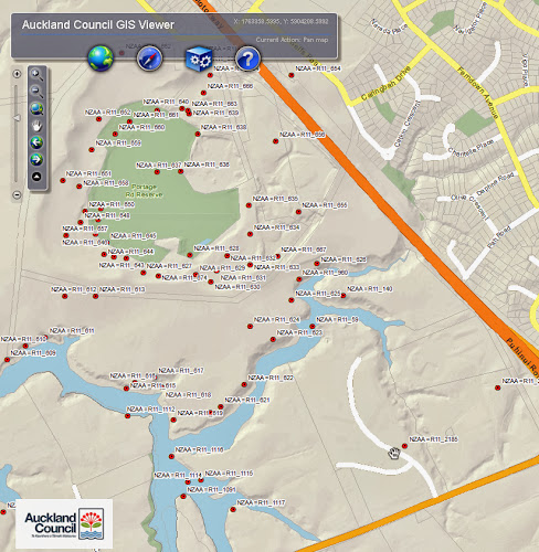
As you drive along Puhinui Road from the airport towards Papatoetoe and Manukau City Centre, you’ll pass some of Papatoetoe’s oldest historic places. These are pa sites that today guard this gateway to Manukau. The major site here is the Papatoetoe Pa (NZAA reference number: R11/59).  The pa was formed on a headland near the upper reaches of the Waokauri Creek, where it controlled the Papatoetoe portage. Papatoetoe Pa was protected on its landward side by a ditch and bank originally about 50 metres long. The pa was about 105 metres in length, 60 metres wide at its broadest point; reducing to 25 metres wide at its tip. Ref: Map showing the headland pa (R11/59), Cultural Heritage Iventory (CHI), Auckland Council GIS Viewer. Please note the data shown in the map provides a rough guide to the site only  The photo below looks down at a branch of the Waokauri Creek from the pa entrenchment. Ref: Footprints 01427, Papatoetoe Pa, 1948, photograph reproduced by courtesy of ...

Remembering the Papatoetoe Orphan Home

Image
Fifty years ago on 5 August 1963 the Health Department's Division of Mental Health began using the former Papatoetoe Orphan Home as a hospital for children with special learning and living needs. The home, also previously and variously known as St John’s Orphanage, St Mary’s Home and the Church of England Orphan Home was now renamed St John’s Home. St John’s Home eventually became a satellite home of the Mangere Hospital (in Robertson Road) for young people with intellectual challanges. Papatoetoe Orphan Home had been laid out according to a 1907 plan by the architect George Selwyn Goldsbro’. Ref: AWNS-19070815-5-1, plan for the proposed orphanage in Papatoetoe, 1907, Sir George Grey Special Collections However because of budgetary constraints it would be built in stages.  Only three of the four dormitory blocks were built initially. (The fourth dormitory block was never built). The blocks were linked by corridors.  There was a dining hall and laundry building behind t...