Posts

Showing posts with the label maps

Awekura - Maps

Image
Awekura is the name given to this blog and podcast series that showcases treasures within Auckland Libraries Heritage Collections, presented by our library specialists.  Awekura is a kupu drawn from Māori weaponry, particularly the taiaha. It refers to the arero, the tongue of the taiaha, which is adorned with kura, red feathers. The term reflects both the physical beauty and their deeper spiritual and narrative significance.  The Heritage Maps collection is an essential resource for researchers, historians, and cartographic enthusiasts. Many of the 10,000 strong map collection items are available to explore on KURA under Heritage Maps . Because their formats vary widely, maps require careful storage; at Auckland Libraries, they are housed in cabinets, tubes, drawers, and specially designed folders. Over her years as Maps Librarian, Katrina helped catalogue the collection and played a key role in establishing the heritage maps presence on our digital platform, KURA .  In ...

Lost Neighbourhoods of Central Auckland - Maps and Early Census

Image
The heritage collections at Auckland Council Libraries offer of wealth of information on the history of our city, including an early census, and map collections that document the built and natural environment at various points in time. Each source has its own strengths, and when looked at together, a picture of Auckland’s lost neighbourhoods can be found. 1842 Map Image: Plan of Auckland as it stands in January 1842. Auckland Libraries Heritage Collections Map 4601 This plan of Auckland as it stood in January 1842 provides many details of the town in its early years. Shortland Crescent (now known as Shortland Street) was the main street at this time. Among the most densely built parts of the town is the area on the southern side of Shortland Crescent where the sites stretch through to Chancery Street. The position of hotels on the map helps show the location of some of the streets we know today. The Sir George Gipps Hotel was located on High Street (marked with the letter M). The a...

Aerial photographs of Manukau from the Auckland Council Archives

Image
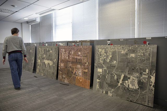
It’s amazing the difference a few decades can make! These aerial photographs of Manukau City from the Auckland Council Archives show the previously open rural landscape to the more built-up area we know today. All showing the same exact location, it is fascinating to realise the growth of Manukau over 25 years, nearly 30 years ago. Image: Photo taken by our Digital Archives Imaging Specialist Paul Chapman showing scale of these aerial photographs and other examples from the accession.  The first image taken in 1972 and still in black and white lacks most of the recognisable landmarks, whereas the other two, taken in 1981 and 1994 are more recognisable with the inclusion of the Manukau Westfield mall and eventually Rainbows End. All of these images were printed on photographic paper pasted in chipboard and the scale here is 2 chains =1” meaning 40 meters = 1 inch approximately. Image: Black-and-white aerial photograph of Manukau City Centre, 14 April 1972, AUC 2023 025 Item 7, Auckl...

Shelter in Place by Celia Walker

Image
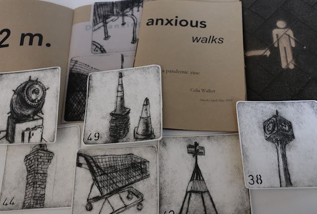
Shelter in Place in the Angela Morton Room at Takapuna library brings together a group of artist books by Auckland printmaker Celia Walker. Landscape, environment and cultural history feature in the exhibition, reflecting the artist’s interest in the complex layers that comprise the urban landscape.  A researcher with a background in archives and histories of landscape, including an art history PhD, Celia can’t help but be influenced by heritage. She is interested in the way each place carries with it stories of our cultural landscape through oral, archaeological and documentary records.  The exhibition also has a cartographic thread – the unfolding and layering possibilities of book structures hint at the passage of time or the movement through space. Although there is an aesthetic appeal in the depiction of underlying structures and forms in maps like Hochstetter’s ‘The isthmus of Auckland with its extinct volcanoes’, these slip over cultural history, detaching the landscap...

Maps by Thomas Wing at Auckland Libraries

Image
Thomas Wing (1810-1888), master mariner, cartographer, harbour master and pilot, was a notable figure in New Zealand’s colonial history. Auckland Libraries has three of his original maps of the west coast of the North Island. They are some of the earliest maps made in New Zealand by Pākehā and are counted among the unique treasures of the library. Wing came from a seafaring family and acquired his maritime knowledge during his youth at the port of Harwich, in Essex, England. He first went to sea aged fourteen and some four years later in 1829 he made his first trip to Sydney on the Ferguson , chartered to transport convicts from Dublin. Although the Ferguson only stayed long enough in Sydney to revictual, Wing would have likely met other mariners and heard talk of New Zealand, the place that was to figure so largely in his later life.  After his return to England, it is believed that the young Wing then joined the Hydrographic Department of the Admiralty where he developed his mari...

The story of an Auckland Tramping Club map

Image
In May 2018, Auckland Tramping Club donated a fascinating map of the Northern Slopes of Mount Ruapehu to Auckland Libraries. Notes on the map indicate the survey was done by C.W. Stewart and J.C.McComish, and it was McComish himself who compiled and hand drew the map, and signed it with the date of October ’57. Further handwritten notes on the map note that it was restored in June 1972 by D.B.F. Brown, which is possibly when the map was laminated. Ref: Auckland Tramping Club, Map of the northern slopes of Mount Ruapehu, 1957. Auckland Libraries Heritage Collections, NZ map 9151. The map covers the area from the Upper Scoria Flat to the Crater Lake and it really is a work of art – mainly black and white, it has roads, streams, huts, ski patrol bases, chair lifts and power lines in colour, although very faded after sixty years of use. As well the map, there is information on safety, distances and the locations of the three telephones on the mountain - essential informat...

The 1950 British Empire Games

Image
After a world war, and an absence of twelve years, the sports fans of the British Empire once again welcomed back the British Empire Games. The year was 1950; the host country, New Zealand. The idea for New Zealand to even consider bidding for the right to host the games came from Mr Alwyn Moon of the NZ Amateur Athletic Association. Mr Moon had observed just how well the 1947 national athletics competition had run in Auckland, and especially how well Eden Park had coped with the intense level of competition at that standard. Moon subsequently called a meeting with like-minded officials to discuss the rather bold proposal: was Auckland in a position to host the 1950 British Empire Games? Ref: New Zealand Herald. Empire Games: Athletics 3rd Day, Eden Park . From: New Zealand Herald Glass Plate Collection. 1950. Auckland Libraries Heritage Collections, 1370-589-24. Representatives from sporting codes across the city believed it was possible and began to explore the venture, w...