Maps by Thomas Wing at Auckland Libraries
Thomas Wing (1810-1888), master mariner, cartographer, harbour master and pilot, was a notable figure in New Zealand’s colonial history. Auckland Libraries has three of his original maps of the west coast of the North Island. They are some of the earliest maps made in New Zealand by Pākehā and are counted among the unique treasures of the library.
Wing came from a seafaring family and acquired his maritime knowledge during his youth at the port of Harwich, in Essex, England. He first went to sea aged fourteen and some four years later in 1829 he made his first trip to Sydney on the Ferguson, chartered to transport convicts from Dublin. Although the Ferguson only stayed long enough in Sydney to revictual, Wing would have likely met other mariners and heard talk of New Zealand, the place that was to figure so largely in his later life.
After his return to England, it is believed that the young Wing then joined the Hydrographic Department of the Admiralty where he developed his maritime survey skills.
In 1832 he arrived in New Zealand, having been offered a position as a crewmember on the Fortitude, the schooner chartered by young entrepreneurs James Reddy Clendon and Samuel Stephenson, who had established a trading base at Okiato, in the Bay of Islands. Stephenson and Wing were first cousins. A map and sketch from the Clendon papers shows their base - it seems likely the chart was done by Wing.
 |
| Image: Manuscript map and sketch of property at Okiato, Bay of Islands. Auckland Libraries Heritage Collections Map 5449. |
From 1832 to 1834 he made journeys around the coast of the North Island, and to Port Jackson as mate of the Fortitude under Captain Henry Wood, and so acquired a good knowledge of New Zealand waters. In November 1834 he made his first voyage down the west coast, when the Fortitude took William Woon and his family to establish a Wesleyan mission at Papakarawa on the northern side of Kawhia Harbour. The Fortitude then sailed back to Māngungu on the Hokianga Harbour, where Wing, and Captain Wood both left the ship.
Wing then took the next step in his sailing career when Stephenson and Clendon appointed him master of their new schooner, the Fanny, which had been built in 1834 at Horeke shipyard at Hokianga. His first voyage as captain of the Fanny, laden with a cargo of potatoes, maize and kauri, was to Sydney, arriving on 15 February 1835; there he secured a license to trade between New South Wales and New Zealand, a requirement for New Zealand-built ships. Fanny returned to Okiato on 11 May, and Wing completed his first trans-Tasman voyage as commander, an impressive achievement, since he was not yet twenty-five years old. Not long after this, he sailed the Fanny to Tauranga, a trip which was not a success in trading terms, but which resulted in the first known sketch map of Tauranga Harbour, which is held at the Alexander Turnbull Library in Wellington.

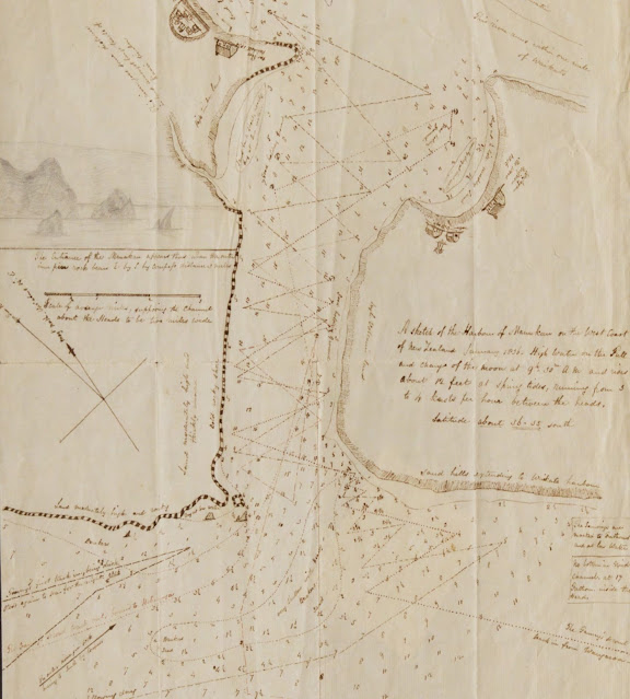
Wing then completed further trips to Sydney and down the East Coast as far as Poverty Bay. Then in late 1835 the Fanny was chartered by Reverend William White to take a group to set up Wesleyan missions further south on the west coast. The voyage started on 29 December, leaving from the mission at Māngungu, and arrived at Kaipara on 6 January 1836.
At White’s request, Wing sailed the Fanny into Kaipara Harbour, being possibly the first European to do so. The Fanny spent 3 days in the Kaipara, and during that time Wing sailed more than 113 km up the Wairoa River, and extended his explorations even further in the ship's boat. The investigations may have been connected to plans the Wesleyans had to establish a station near to Tangiteroria, which they did some five months later.
As a result of his research around the harbour, Wing drew the first known survey sketch chart of its complicated entrance way, a map which is now held by Auckland Libraries.
 |
| Image: Chart of the entrance to Kaipara Harbour, drawn by Captain Thomas Wing, January,1836. Auckland Libraries Heritage Collections Map 4613. |
The features he sketched can be still seen on a nautical chart produced many years later.
 |
| Image: Kaipara Harbour [1996]. Auckland Libraries Heritage Collections Map 7109. |
Thomas Wing's Chart of the entrance to Kaipara Harbour was displayed in the Special Collections Reading Room at Tāmaki Pātaka Kōrero, Central City Library, in 2020. Listen to map librarian Katrina Laan talk about the chart in this track from the Kura Tūturu / Real Gold podcast series.
The Fanny then proceeded to the Manukau Harbour where Reverend White hoped to secure a site for the Wesleyan Mission, arriving on 9 January 1836. While the land deals were being concluded, Wing once again took soundings and produced the first detailed survey of the Manukau Harbour entrance. That chart is held at the Hocken Library, Dunedin.
 |
| Image: Thomas Wing. Manukau Harbour entrance. Uare Taoka o Hākena: Hocken Collections Maps Manuscript HMapM 842.851 1836 aj. |
The Fanny sailed on down to Kawhia, arriving on 12 January to collect the Rev. William Woon and his family to take them back to Manukau. Once again Wing produced a chart of the harbour, although he would have already been familiar with the waters, having made an earlier visit in November 1834. Wing’s chart is not the first made of Kawhia Harbour, but it is interesting because of the detail, showing the mission stations and Māori village (complete with a waka) on Albatross Point.
 |
| Image: Chart of Kawhia Harbour, drawn by Captain Thomas Wing, 1836. Auckland Libraries Heritage Collections Map 4612. |
And a more modern chart of Kawhia Harbour:
 |
| Image: Kawhia Harbour, surveyed by B. Drury, P. Oke and H. Ellis, 1854, corrections to 1920. Auckland Libraries Heritage Collections Map 3694. |
On the return voyage to Manukau, the Fanny ventured into Whaingaroa Harbour (Raglan) on an overnight visit to deliver supplies to the Wesleyan Mission station at Te Horea, and Wing took the opportunity to survey the entrance to the harbour.
 |
| Image: Whaingaroa Harbour, sketch drawn by Captain Thomas Wing, January, 1836. Auckland Libraries Heritage Collections Map 4605. |
And a more modern chart to compare with Wing's.
 |
| Image: Raglan Harbour. Auckland Libraries Heritage Collections Map 5045. |
Having taken Woon and family back to the Manukau, Wing sailed the Fanny back to Hokianga, arriving on 30 January, and then on to his base at Okiato on 17 February 1836. So ended a voyage that resulted in harbour charts that have survived to this day.
Brian Byrne, author of the authoritative biography Wing of the Manukau suggests that Thomas Wing visited England in 1839, and he while there, showed his sketch charts - he had also done survey work at Napier and Tauranga - to two of London's leading map publishers - James Wyld the younger and John Arrowsmith. The information Wing provided was incorporated into Wyld's 1841 chart, shown below.

Arrowsmith published a chart in a year later in June 1842, that included Wing's soundings and notes.
Wing's work had contributed to the ever-growing published knowledge about the waters around New Zealand.
Thomas Wing went on to have a distinguished career. He was the first European to sail into the Waitematā Harbour in late 1836 and he sailed the surveyors to the site of New Edinburgh (Dunedin) in 1844. He lived in the Bay of Islands, in Launceston, Tasmania, and in Melbourne. In 1857 he was appointed harbour master and pilot of Manukau Harbour, a post he held for 30 years. It was during his tenure that the Orpheus was wrecked at the Manukau entrance in February 1863, an event which finally led to the navigational improvements he had long pushed for.
 |
| Image: Timothy Brian Byrne, . Photograph of Thomas Wing, 1810-1888. Ref: PAColl-7246. Alexander Turnbull Library, Wellington, New Zealand. /records/23033926. |
Thomas Wing died at Māngere on 19 August 1888 and his passing was noted in an obituary in the New Zealand Herald. He was buried at Saint Peter’s Anglican Church, Onehunga, and his grave now lies beneath the footprint of the 1980 church alterations.
The maps now at Auckland Libraries were gifted to the Old Colonists' Museum and were transferred to the library when that museum closed in 1957.
Sources:
T.B. Byrne. The unknown Kaipara. Auckland: T.B. Byrne, 2002.
T.B. Byrne. Wing of the Manukau. Auckland: T.B. Byrne, 1991.
T. B. Byrne. 'Wing, Thomas', Dictionary of New Zealand Biography, first published in 1990. Te Ara - the Encyclopedia of New Zealand. https://teara.govt.nz/en/biographies/1w33/wing-thomas (accessed 24 May 2020).
‘Historic charts coast and harbours,’ New Zealand Herald, 2 September 1932, page 8, https://paperspast.natlib.govt.nz/newspapers/NZH19320902.2.27.
'Obituary,' New Zealand Herald, 10 September 1888, page 10, https://paperspast.natlib.govt.nz/newspapers/NZH18880910.2.55.
'Thomas Wing. Chart of the entrance to Kaipara Harbour,' Real Gold Treasures of Auckland Libraries. http://www.aucklandcity.govt.nz/dbtw-wpd/virt-exhib/realgold/NewZealand/thomas-wing.html.
www.graveinsightsonehunga.nz (accessed 6 December 2021).
Author: KL
Captain Thomas Wing was Sir Peter Blake's great-great-grandfather - both great men of the sea!
ReplyDeleteHis Son Edward Wing was on the Signal Station on the 7th February 1863 when the H.M.S Orpheus struck the outer middle bank of the Manukau harbor, the Vessel ignoring the signals from the signal station.
ReplyDelete