During the late nineteenth century, uncontrolled urban development in Auckland resulted in cramped inner-city houses built along narrow streets and lanes. These small houses were usually serviced by cesspits or insanitary drains and sewers, and often had backyard middens. Even in the early twentieth century, large blocks of such substandard housing remained in the central city not far from Queen Street.
However, since the 1870s, city officials had been urging that modern cities needed to be planned and developed in a more orderly, tidy, sanitary and visually attractive way. Responding to current town planning ideas, in 1911, the
New Zealand Graphic began a new social crusade. It informed its shocked middle-class readers that working-class housing fit only for demolition festered as close at hand as mid-city Federal and Cook Streets, and in upper-city Alexandra Street. And there were other poor housing areas at the western ends of Victoria and Wellesley Streets too. Below are some of the
Graphic’s ‘slum’ photographs.
 |
Image: New Zealand Graphic. The crusade against dirt and disease…, 19 July 1911,
Auckland Libraries Heritage Collections, NZG-19110719-25-1.
|
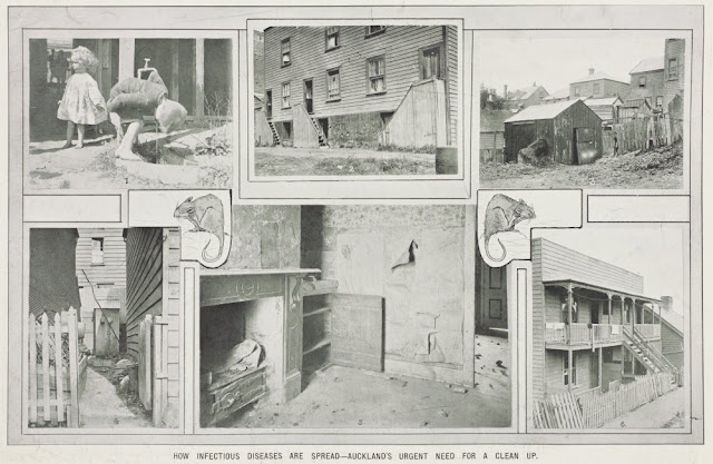 |
Image: New Zealand Graphic. How infectious diseases are spread - Auckland's urgent need for a clean up,
12 April 1911, Auckland Libraries Heritage Collections, NZG-19110412-23-1. |
However, the
Graphic soon realised that slum clearance, or even just the creation of new suburbs, often led to another urban problem; the unregulated or largely uncontrolled construction of cheap, substandard and overcrowded subdivisions by unscrupulous and profit-driven developers. In October 1911, the paper investigated the development of new industrial suburbs at Onepuhi Estate, Miramar and Kilbirnie on the Kilbirnie Flat in Wellington.
 |
Image: New Zealand Graphic. Kilbirnie Flat, showing how commercial land speculation is parcelling out land…,
25 October 1911, Auckland Libraries Heritage Collections, NZG-19111025-29-4. |
The
Graphic’s judgements on the problems of unregulated town planning is shown by the photographs it published. They show overcrowded subdivisions where developers had maximised the number of small houses they could build by squeezing them onto small sections with tiny boundaries and yards.
 |
Image: New Zealand Graphic. 20 and 22ft frontages—houses are only five years old, 25 October 1911,
Auckland Libraries Heritage Collections, NZG-19111025-29-1.
|
 |
Image: New Zealand Graphic. Suburb-making on Kilbirnie Flat, 8 November 1911,
Auckland Libraries Heritage Collections, NZG-19111108-29-1. |
In Kilbirnie, the
Graphic’s photographer took the following amazing photograph, where a brick shed had been built right up to the boundary of the house behind it. The house (which was there first) had also been built up to the edge of its section boundary. Perhaps it was too large for its tiny section.
 |
| Image: New Zealand Graphic. House spoiling. Fine new house blocked up by back of brick shop, 25 October 1911, Auckland Libraries Heritage Collections, NZG-19111025-29-2. |
But this did not only happen in Wellington. In Auckland another
Graphic photographer took the following photograph of houses being built too close to existing boundaries in Ponsonby’s new Jervois Estate.
 |
Image: New Zealand Graphic. Speculative building in Auckland..., 1 November 1911,
Auckland Libraries Heritage Collections, NZG-19111101-28-2. |
Since about 1903, developers had been creating the Jervois Estate along Jervois Road in Ponsonby. The
Graphic’s judgement was that here, too, unscrupulous developers largely uncontrolled by lax town planning by-laws had increased their profits by jamming as many houses on small sections as they could into the subdivison. This had resulted in the creation of a visually unattractive, featureless suburb of uniformly monotonous houses crammed together along endless roads with few intersecting thoroughfares and no developer-provided public parks or reserves.
 |
Image: New Zealand Graphic, What commercial land speculation provides in New Zealand, 1 November 1911,
Auckland Libraries Heritage Collections, NZG-19111101-29-2. |
Furthermore, the Graphic observed that the same thing was happening along the endless roads in the Ponsonby Park Estate, also recently developed nearby.
 |
Image: New Zealand Graphic. The march of roof iron and chimney pots, 1 November 1911,
Auckland Libraries Heritage Collections, NZG-19111101-30-1. |
Inevitably, the
Graphic compared Auckland’s uncontrolled town planning shambles with orderly and attractive suburbs in new towns like Port Sunlight and Bournville in England. The following photographs compare New Zealand laissez-faire with orderly English town planning.
 |
Image: New Zealand Graphic. Port Sunlight and the Jervois Estate, 1 November 1911,
Auckland Libraries Heritage Collections, NZG-19111101-29-1.
|
 |
Image: New Zealand Graphic. What town planning provides in England, 1 November 1911,
Auckland Libraries Heritage Collections, NZG-19111101-29-3. |
The photograph below shows what the Jervois Estate looked like seven years after it was created.
 |
Image: New Zealand Graphic. Five to seven years' growth—what the Jervois estate cost the public, 1 November 1911, Auckland Libraries Heritage Collections, NZG-19111101-28-1.
|
The
Graphic complained that Auckland ratepayers had been left to pay for adequate roads and footpaths in the Jervois Estate, because when the subdivision was completed there were no effective planning by-laws regulating the standards of the shoddy thoroughfares developers usually provided. Therefore unscrupulous developers could expand their returns even further; saving space (and money) by jamming in houses while scrimping on roads and footpaths.
On 1 November 1911 the
Graphic published the following photograph of unfinished roads and footpaths in a new suburb (probably the Ponsonby Park Estate), which had not been completed by developers who were up to their usual unscrupulous tricks.
 |
Image: New Zealand Graphic. New roads and footpaths in a new suburb, 1 November 1911,
Auckland Libraries Heritage Collections, NZG-19111101-30-2.
|
And it seems the more things change, the more they stay the same. Fifty-five years later in 1966 an unknown photographer took the following photograph of Mrs Dorothy Laker and her young son, Gavin, walking down an unsealed section of Flat Bush Road in Otara because there was no footpath.
 |
| Image: Unknown photographer. Woman with a pram, Otara, July 1966. Auckland Libraries Heritage Collections Footprints 00060. Photograph reproduced by courtesy of Stuff Limited. |
In other new suburbs like Manurewa, Mangere and East Tamaki the roads and footpaths were pretty basic.
 |
| Image: Unknown photographer. Neglected street, Manurewa, April 1970, Auckland Libraries Heritage Collections Footprints 08395. Photograph reproduced courtesy of Stuff Ltd. |
In most cases, developers built houses and moved on. Consider this photo from East Tamaki in 1961 where no footpaths have been laid out, and the houses came complete with gorse in their backyard paddocks! There is nothing new under the sun, and uncontrolled developers seldom change their spots…
 |
| Image: Elizabeth Andrews. Group Housing Project, East Tamaki, May 1961, Auckland Libraries Heritage Collections Footprints 05122. |
Author: Christopher Paxton, Heritage Collections
Further reading:
Ben Schrader.
City planning, retrieved from Te Ara - the Encyclopedia of New Zealand, published 11 Mar 2010, updated 26 Mar 2015.


Comments
Post a Comment
Kia ora! Please leave your comment below.