Making a model city: the origins of the Central Area Model
The Central Area Model is a 1:480 scale model of central Auckland carefully built during 1967 and 1968 to replicate the city in precise miniature. The model recreates the areas of central Auckland bordered by the motorways which now surround the inner-city area. For more than two decades Council planners used the model to visualise the way proposed construction would alter the character and physical spaces of the city.
The Council displayed the model for public exhibition multiple times over the years. In fact, the model went on public display at Milne and Choyce department store on Queen Street almost immediately after completion. Now, more than 50 years after its creation and over a decade since its last public appearance, the Central Area Model is on display once more -- this time on the ground floor of the Central City Library till 21 July 2022.
The model replicated Auckland almost exactly as it stood in 1968. Around 4000 buildings, carved from cedar, recreated the shapes of every standing or consented building to scale. The model precisely recreated the landscape thanks to careful mapping. The model showed the completed motorway system which now wraps around the central city. The presence of the future motorways in the otherwise exact recreation hinted at the reasons for its creation.
The Auckland City Council, however, was not entirely satisfied with De Leuw Cather’s work. City Engineer Arthur Dickson complained the proposals were “a statement of the conclusions of the Consultants rather than a technical report accompanied by all basic relevant information.” De Leuw Cather’s report lacked a complete account for how the Central City would accommodate the greatly increased traffic volumes the new motorways could funnel into the area. In 1966, the City Council subsequently engaged British consultant Dr. Colin Buchanan to provide specific planning advice on this matter.
Buchanan’s report explained that he could not deliver the advice requested as the Council did not have a comprehensive development plan for Central Auckland. As Graham Bush commented in his history 'Advance in Order': “for most of its first century the Council had no inducement to place the central city on any special pedestal of attention.” During the 1960s this thinking had begun to change and Buchanan’s report provided a set of grounding principles for a dedicated central development section. The Council formed this team before the end of 1966, culminating in the delivery of the Central Area Plan in 1974. This document systematically codified the development of Central Auckland for the first time.
Computing was not the only technique imported from overseas by this new team. One of the two staff assigned to build the Central Area Model was Tony Warren, a scale model-making specialist fresh from a year of study in London. Warren was only twenty-years-old at the model’s completion. The Auckland Star reported Warren was “believed to be the only specialist in his field living in New Zealand.” Nick Stanish, then a graduate architect, worked with Warren on the production of the model. Stanish would go on to serve in the planning department for many years.
The process of making the model began with aerial survey photography captured in 1966. These photographs captured elevation information and formed the basis of highly detailed maps marking the shape and position of every street, structure, and landform. These maps were then enlarged to meet the model’s scale and used to precisely create the dimensions of terrain and structures in each segment of the model.
Work on the physical construction of the model city began in early 1967 after Nick Stanish reserved the necessary space on the 16th floor of the Civic Administration Building.
The Central Area Model was constructed in sections to aid movement and allow better access to different areas of the model. Each section began with a timber base over which sheets of polystyrene were laid to create the topographic shape of each section. Painted gypsum plaster formed the surface layer. The roads were made of painted cardboard and buildings from cedar, left unpainted. Trees, created by attaching pieces of painted sponges or old mattresses to wire, dotted the model’s landscape to depict the greener areas of the city. The cost of these materials amounted to relatively little; less than the cost required to construct the partition where Stanish and Warren worked. Time was by far the greatest expense, as the pair worked full time for over a year and a half to complete the model.
Since the model was intended to visualise new proposals, the buildings were designed to be removed and swapped out. During the 1970s some developers produced their own model buildings to present their proposals to Council or, sometimes, even their own clients. But during the 1980s the planning department began requiring developers to supply these models in submissions. Evidently a considerable number of buildings were modelled over the decades, more model buildings survive than can fit onto the model at any one time.
Still, the model city inspires fascination through its sheer size. It remains a tangible link back to decades of planning work which produced Auckland as we know it today. Even half a century after its creation, it is still worth seeing. Come along to the Central City Library to see the model up close!
Author: Liam Appleton (Central Research)
The Council displayed the model for public exhibition multiple times over the years. In fact, the model went on public display at Milne and Choyce department store on Queen Street almost immediately after completion. Now, more than 50 years after its creation and over a decade since its last public appearance, the Central Area Model is on display once more -- this time on the ground floor of the Central City Library till 21 July 2022.
.jpg) |
| Image: Liam Appleton. The Central Area Model in the Model City display on the ground floor of the Central City Library, May 2022. |
The Auckland City Council unveiled the Central Area Model in late August 1968. “The 25ft-long model of the Auckland city area isn’t just an expensive showpiece,” wrote the Auckland Star. “It’s an aid which is built exactly to scale and will be used to see how each proposed new development will fit in with the surroundings.” The model is about twenty square-metres in size and recreated 825 acres of the Central City soon to be enclosed within new motorways.
.jpg) |
| Image: Mayor McElroy pictured with model and model maker Tony Warren. Auckland Star photograph, 30 August 1968, from the Works Department Clippings, Auckland Council Archives. |
Paving the way
The commissioning of the Central Area Model began with the delivery of a regional transport plan by consultants De Leuw Cather in 1965. Two years earlier, the Auckland Regional Planning Authority commissioned the firm to produce a plan for the next two decades of transport development in Auckland. The local authorities readily accepted the De Leuw Cather report's planning for extending roads and motorways. De Leuw Cather's plans expanded on the 1955 Master Transport Plan which imagined the city's future motorway system.The Auckland City Council, however, was not entirely satisfied with De Leuw Cather’s work. City Engineer Arthur Dickson complained the proposals were “a statement of the conclusions of the Consultants rather than a technical report accompanied by all basic relevant information.” De Leuw Cather’s report lacked a complete account for how the Central City would accommodate the greatly increased traffic volumes the new motorways could funnel into the area. In 1966, the City Council subsequently engaged British consultant Dr. Colin Buchanan to provide specific planning advice on this matter.
 |
| Image: Cover of Central Area Plan by the Town Planning Department of Auckland City Council, Auckland Council Archives: ACC 340/152. |
Buchanan’s report explained that he could not deliver the advice requested as the Council did not have a comprehensive development plan for Central Auckland. As Graham Bush commented in his history 'Advance in Order': “for most of its first century the Council had no inducement to place the central city on any special pedestal of attention.” During the 1960s this thinking had begun to change and Buchanan’s report provided a set of grounding principles for a dedicated central development section. The Council formed this team before the end of 1966, culminating in the delivery of the Central Area Plan in 1974. This document systematically codified the development of Central Auckland for the first time.
Building the model
The proposal to construct a scale model of the name-sake Central Area arose during the proposal stage of the Central Area Section. “It is essential that we have the means to simulate the features of both the ‘anatomy’ and the ‘physiology’ of the future central area of Auckland”, Arthur Dickson wrote to the Councillors. To this end, Dickson proposed to equip the team with both a physical model as well as access to the developing field of computing for data modelling. Dickson, observant of overseas developments, noted how computer modelling had recently begun to find use by planners the United Kingdom and United States. The City Council approved the central area section and the model in December 1966. |
Image: A close up view of Aotea Square on the Central Area model, Auckland Council Archives, AKC 2008 005. |
Computing was not the only technique imported from overseas by this new team. One of the two staff assigned to build the Central Area Model was Tony Warren, a scale model-making specialist fresh from a year of study in London. Warren was only twenty-years-old at the model’s completion. The Auckland Star reported Warren was “believed to be the only specialist in his field living in New Zealand.” Nick Stanish, then a graduate architect, worked with Warren on the production of the model. Stanish would go on to serve in the planning department for many years.
The process of making the model began with aerial survey photography captured in 1966. These photographs captured elevation information and formed the basis of highly detailed maps marking the shape and position of every street, structure, and landform. These maps were then enlarged to meet the model’s scale and used to precisely create the dimensions of terrain and structures in each segment of the model.
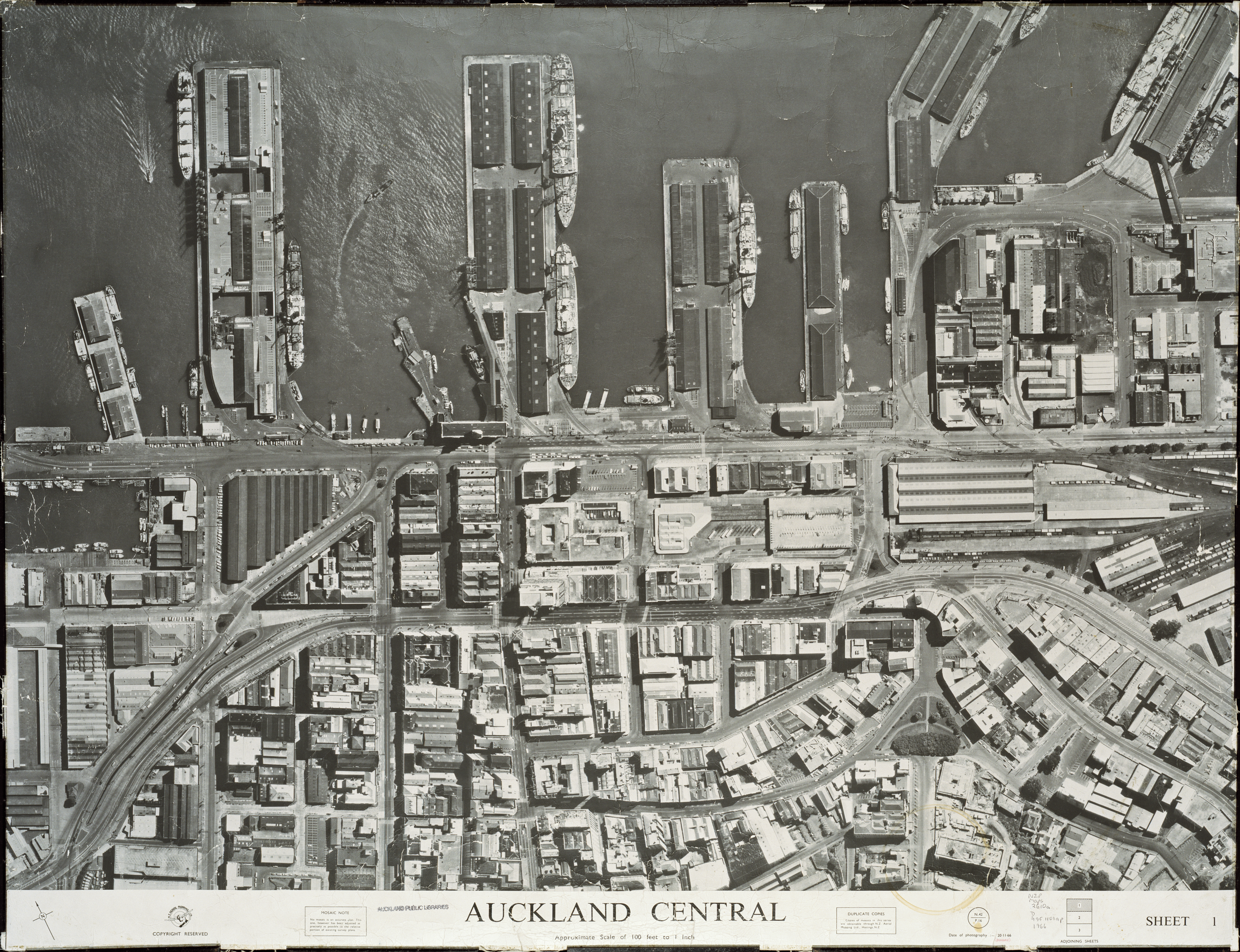 |
| Image: An aerial photograph of part of downtown Central Auckland, 1966. Auckland Libraries Heritage Collections, Map 2610a. |
Work on the physical construction of the model city began in early 1967 after Nick Stanish reserved the necessary space on the 16th floor of the Civic Administration Building.
The Central Area Model was constructed in sections to aid movement and allow better access to different areas of the model. Each section began with a timber base over which sheets of polystyrene were laid to create the topographic shape of each section. Painted gypsum plaster formed the surface layer. The roads were made of painted cardboard and buildings from cedar, left unpainted. Trees, created by attaching pieces of painted sponges or old mattresses to wire, dotted the model’s landscape to depict the greener areas of the city. The cost of these materials amounted to relatively little; less than the cost required to construct the partition where Stanish and Warren worked. Time was by far the greatest expense, as the pair worked full time for over a year and a half to complete the model.
In use
In 1966, Arthur Dickson had argued the value of a physical model would be “fully justified” as a means for planning staff to analyse the visual impacts of proposed developments, but also to engage with developers and the general public. Throughout the model’s operational lifetime, the Council offered viewings to a range of visitors including school and university students, as well as interested members of the public.Since the model was intended to visualise new proposals, the buildings were designed to be removed and swapped out. During the 1970s some developers produced their own model buildings to present their proposals to Council or, sometimes, even their own clients. But during the 1980s the planning department began requiring developers to supply these models in submissions. Evidently a considerable number of buildings were modelled over the decades, more model buildings survive than can fit onto the model at any one time.
.jpeg) |
| Image: Showing the scale of the Central Area Model in 1987, including the gantry used by planning staff to view it. Image from: Graham Bush's book 'Advance in order'. |
While simple observation allowed planners to observe the visual changes of new buildings, they could also employ additional methods. Through a modelscope, a type of specialised endoscope, a viewer’s perspective could be reduced to resemble the model’s scale and simulate the street level perspective. The planning department also obtained a gantry to sit over the model to provide staff greater accessibility, visible in the image above. Changes in lighting and shading could be studied by simulating the position of the sun with a calibrated spotlight. Notes on an old informational brochure indicate the Council even experimented with using the model for wind tunnel testing. For presentations to visitors and Councillors, more rudimentary tools sufficed. “A long wooden pointer has proved adequate to identify buildings and other features of the city,” wrote Director of Planning B. Berrett in 1976 in response to the enquiries from the Brisbane Development Association.
 |
Image: Person studying the model using an endoscope or modelscope. Auckland Council Archives, AKC 2008 005. |
Berrett also tempered his advice to the Australian enquirers with frank admissions of the Central Area Model’s shortcomings. Evidently, the Brisbane Development Association were considering making their own model. “The size of the assembled model, together with the pressures for office floor space, has resulted in the structure being moved… frequently” Berrett explained. Transporting the model tended to result in buildings falling off when staff turned the sizeable sections sideways to manoeuvre the pieces through doorways. The handling required to move the model’s segments between display and storage spaces caused damage it as well. Berrett described how the polystyrene layers of the landforms had begun to delaminate or break as glues deteriorated and materials grew brittle with time.
.jpg) |
| Image: Liam Appleton. Photograph of the damaged Grafton Bridge section of the Central Area Model, May 2022. |
The model required regular maintenance because of such wear and tear, as well as the need to keep the layout current with changes to the city’s actual state. While the materials were inexpensive, repairs represented a not-insignificant cost given the painstaking and time-consuming nature of precise model work. To limit the costs of annual repairs the planning department later hired university students to perform the work over holiday periods rather than hire more expensive professional designers or architects.
While the model could be repaired, the problem of space lacked a clear solution. Although built on the 16th floor of the administration building and then moved to the second floor, by the mid-1970s the planning department had shifted the Central Area Model into the Town Hall. The model remained there in a top-level room for more than ten years. In 1983, a planner complained that the distant location was inconvenient for the planning team and the old draughty room unwelcoming for visitors. However, the Council did not move the model until 1989 when Town Hall renovations forced the decision. Fortunately, due to movements of administrative teams, the planning committee found space for the model city near the urban planning offices. The committee even approved two new segments to add -- the viaduct and former railway yards -- which would have substantially increased the model’s total area. However, it does not appear these additional pieces were ultimately constructed.
While the model could be repaired, the problem of space lacked a clear solution. Although built on the 16th floor of the administration building and then moved to the second floor, by the mid-1970s the planning department had shifted the Central Area Model into the Town Hall. The model remained there in a top-level room for more than ten years. In 1983, a planner complained that the distant location was inconvenient for the planning team and the old draughty room unwelcoming for visitors. However, the Council did not move the model until 1989 when Town Hall renovations forced the decision. Fortunately, due to movements of administrative teams, the planning committee found space for the model city near the urban planning offices. The committee even approved two new segments to add -- the viaduct and former railway yards -- which would have substantially increased the model’s total area. However, it does not appear these additional pieces were ultimately constructed.
.jpeg) |
| Image: Auckland MPs receiving a tour of the Central Area Model in the Civic Administration building, 1970. From: Graham Bush's book 'Advance in Order'. |
Eventually though, the model became functionally obsolete. Advancements in computer technology allowed for modelling and simulation of visual changes without the considerable space requirements of a physical model. At some point the planning department placed the Central Area Model into storage, where it has largely remained for well over a decade, aside from a handful of public appearances. Moved multiple times and no longer with regular maintenance, the model now clearly shows its age. At least one of the segments is completely missing.
Still, the model city inspires fascination through its sheer size. It remains a tangible link back to decades of planning work which produced Auckland as we know it today. Even half a century after its creation, it is still worth seeing. Come along to the Central City Library to see the model up close!
Author: Liam Appleton (Central Research)
Acknowledgements
Very special
thanks to Vicky Spalding and Owen Gordon (Auckland Council Archives) whose research made this
piece possible, and acknowledgements to all staff who contributed to the Model
City exhibition.
References
ACC 219,
Works Department Classified Subject Files (1901-1993), Auckland Council
Archives, Auckland.
ACC 438,
City Engineers Works Department Newspaper Clippings (1910-1980). Auckland
Council Archives, Auckland.
Bush, Graham
W. A., Advance in Order: The Auckland City Council from Centenary to
Reorganisation 1971-1989, Auckland: Auckland City Council, 1991.
Bush, Graham
W. A., Decently and in Order: The Government of the City of Auckland
1840-1971, Auckland: Collins, 1971
Central
Area Plan, Auckland
City Council: 1974.
Dickson, A.
J., “Reports Prepared by DeLeuw Cather and Company 1966”, Auckland City
Council, 1966.
“Model Took
Two Years to Set Up”, New Zealand Herald, 24 August 1968.
National Roads Board, Auckland Motorways, 1973.
Comments
Post a Comment
Kia ora! Please leave your comment below.