Posts

Showing posts with the label Waitakeres

Calling all petrol heads
Image
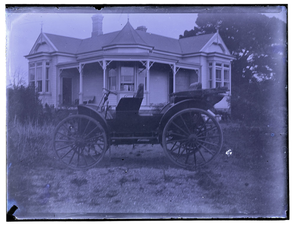
Do you love cars? The sleek lines, revving engine and the smell of an oily rag? Well have we got a blog post for you! Drawn from the collections at the North and West Auckland Research Centres, we have vintage cars galore plus images of car rallies all set in the landscapes of the North Shore and West Auckland. The introduction of cars 100 years ago revolutionised the way people lived, worked and spent their leisure time. Suddenly getting from A to B was much quicker and more efficient, opening up opportunities for people to take outings and trips. Like all  places around the world, the introduction of the car also brought a radical change in the landscape and the way towns were laid out and operated and some not so pleasant side effects, such as pollution. Keen to find out more? Check out this great visual history of the car in NZ  and browse through the heritage resources at Auckland Libraries. Pre-1920s cars: Ref: Frank Morris, international buggy, location u...

Bowling

Image
Since Monday's post was all about keeping fit, it seemed a good idea to keep those motivation levels high and devote Friday's post to bowling. A gentle way of keeping fit but with benefits of all the socialising that goes along with it! Bowling can also have a heritage component too. Now for a look back in time at the large number of bowling clubs, which sprung up in the Auckland region over the years, particularly in the first decade of the 20th century. Check out the wonderful array of clothing worn by the Mount Eden and Ponsonby bowlers in 1900. It must have been pretty hard to bowl in those formal outfits! Grafton/The Domain: Ref: AWNS-19011031-1-1, Auckland Bowling Club's Grafton Green on opening day, 26 October 1901, Sir George Grey Special Collections Mount Eden: Ref: 1-W1220, looking SW from Mount Eden - showing Mount Eden Bowling Green, 1905, Sir George Grey Special Collections Ref: AWNS-19001012-8-2, opening of the Mount Eden Bowling Green, 6 Oct...

Piha Radar Station

Image
Ref: JTD-04A-01111, Piha Number 4 Radar Station antenna, 1958, West Auckland Research Centre The Piha Radar Station was constructed during WW2 by the NZ Air Force. Located at the end of Log Race Road in the Waitakere Ranges Regional Park, it was part of a network of radar stations along New Zealand's coast. The purpose of this site was to use radio wave transmission aerials and receiving equipment to detect any signs of attack from enemy aircrafts or vessels. Ref: JTD-04J-01110, Te Ahuahu Road and radar station, 1958, West Auckland Research Centre The site was closed permanently in the 1950s and the buildings and other structures removed. However, there are remains that can still be seen, including the concrete pads where the aerial tower once stood. Ref: JTD-04A-00307-1, remains at radar station site and Hikurangi beacon, 1963, West Auckland Research Centre This site has been added to the schedule of significant historic heritage places in the Proposed Auckland Uni...

The Ken Abercrombie Collection

Image
This blog post looks at the Abercrombie family’s outings during the 1930s and 1940s. The memories of this West Auckland family were documented by Ken Abercrombie through 4 photo albums of exquisite hand-coloured family snaps. These albums are held at the West Auckland Research Centre and you can view the first album online . A significant and attractive feature of the albums is that the majority of the prints have been hand-coloured and captioned by the photographer. Ref: KRA-PA-02-049-00, Ken Abercrombie, Album 2, West Auckland Research Centre Ken Abercrombie (b.1916) was a keen photographer, first becoming interested as a 16 year old boy when his parents gave him a camera – a ‘Balovo’, a German make. Ref: Ken Abercrombie's camera, early 1930s, West Auckland Research Centre At this time the Abercrombie family were living in Blockhouse Bay where Ken’s father, Roy had started a carrying business. The photo below shows his International truck. Ref: KRA-PA-02-031-04, ...

The mills at Riverhead

Image
Located on the western banks of the Ranitopuni River, below the Riverhead Bridge, is an old mill site. Initially a timber mill, the mill was powered by water (1845-1856). Subsequently, the Waitemata Flour Mill was built on the same site in 1855/1856 and was operated by J. Brigham (until 1859). J. Lamb took over the site after Brigham and ran it until around 1888. The mill was vacant for 2 years before the Riverhead Paper Mill opened and ran until its closure in 1923. Ref: 80-BIN247, John Lamb's Waitemata Mills at Riverhead, c. 1900, Sir George Grey Special Collections The paper mill company that took over the site had examined several old flour mill sites before choosing the former Lambs Mill. The site was particularly attractive because of the plentiful freshwater supply and access to cheap harbour transport. Before opening, the mill under went major reconstruction. It was entirely steam powered, with coal brought up the harbour and unloaded at a special wharf at the site. T...

Family History, Local History: Marge Harré, the early years, Pt 2

Image
The blog post on the 4 December 2013 introduced Marge Harré and her family's involvement with the Roadhouse restaurant in Oratia. The Clark and Gardner families with whom Marge was related, played a leading role in the growth of West Auckland’s brick and clay industry. 'The sons of Louisa (Clark) and John Gardner made bricks in New Lynn. Between 1922 and1925 they made nearly 21 million' (p.15, ' Roadhouse Days '). Louisa (Gan) Clark/Gardner (Marge's grandmother) lived at the Gardner house at Glorit until some of the family moved down to New Lynn in 1898. The house, named Mataia Homestead ,  is located on the Kaipara Coast Highway . Gan moved down there a little later, probably around the early 1900s. The photo below is from the early 1930s, when Gan went back to visit the house. Ref: Gan in hat in front of House at Glorit, from the Harre Family Collection, c. 1930s, West Auckland Research Centre Marge’s mother, Ellen (Gardner) Miller died 11 months after...

Marge Harré: an enterprising woman, a restaurant & a West Auckland family, Pt 1

Image
Marge Harré’s story is one of an enterprising and, by all accounts she was an extremely engaging and unique character. She left behind a lasting legacy - one that connects, a house, a community, her wider family history, and the history of West Auckland. Her most enduring legacy has been provided in the book, 'Roadhouse Days: an account of a family, a house and a restaurant' by Drew Harré and David Harré (2009). 'Roadhouse Days' tells the story of Marge and her family’s involvement in the Town and Country Roadhouse Restaurant (1949 to c.1968) in Oratia, West Auckland. Written by Marge’s son, Dave Harré and Dave’s nephew, Drew Harré, this book contains entertaining anecdotes, recollections as well as accounts based on historical records. Many of Marge’s recipes are also included at the end of the book. Ref : JTD-13A-01995-1,  Oratia Bowling Club pavilion. (Parr Homestead in background), 1963, West Auckland Research Centre The original Roadhouse restaurant...

Dams out West

Image
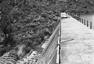
Many people would not think of dams as being heritage assets, but there a number of historic but still operational dams in the Auckland region. Ref: JTD-07B-03192, Huia Dam, 1941, West Auckland Research Centre The Waitakere Ranges Water Supply System draws water from the ranges in West Auckland including the Huia, Nihotupu and Waitakere streams. During the 20th century, five large dams were constructed. These created the a series of reservoirs and associated tramways, piping, tunnels and filter stations. The main dams which are still in use include: the Waitakere Dam (1910), Upper Nihotupu Dam (1923), Upper Huia Dam (1929), Lower Nihotupu Dam (1948) and the Lower Huia Dam (1971).

Whatipu Post Office

Image
Ref: JTD06E-04475-2, Paratutai Island (foreground), 1977, West Auckland Research Centre Did you know that there was once a small wooden Post Office located at Paratutai Wharf at the base of Paratutai Island in the Waitakere ranges? The building was subsequently relocated to Whatipu, a short distance away. The building is a simple shed with weatherboard walls and corrugated iron gabled roof. It was built between 1870-1909. Ref: JTD-06A-00191, Whatipu Post Office and wharf, 1907, West Auckland Research Centre The building is now part of the Whatipu Lodge complex , located among the dramatic scenery of this area. It has provided accommodation for sightseers for nearly a century. The complex includes the Former Post Office, the Gibbons Homestead (built circa 1867), the four Cabin Blocks (built in 1910) and the Former Dairy (construction date unknown). So if you go and stay at these heritage building during your holidays, have a look around you and you will be rewarded with gli...