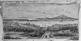
One of the themes for the heritage festival is Auckland’s waterways, including the land and sea. The events focused on this theme celebrate water and its many guises in the Auckland region, including as a source of travel, trade, economy, recreation and more.
Auckland's geography and its waterways have intimately influenced the history of the region. The Auckland isthmus was a rich and desirable location for Māori for many reasons including the rich volcanic soils for gardening and the coastal resources.
It was also a strategic hub between the North and South, East and West and was well connected by the network of sheltered waterways and canoe portages between the Kaipara, Waitemata and Manukau Harbours and the Waikato River to the South. Indeed the very name Tāmaki-makau-rau / Tāmaki of a hundred lovers, refers to this desirability of location and resources.
The attractiveness of Auckland was also quickly recognised by Europeans during early colonial settlement. For these reasons and the close proximity of Māori close by, William Hobson, the first Governor of NZ chose Auckland as the new capital in 1840. Indeed Anthony Trollope, an English novelist wrote in 1873 that:
'Its ports have been the making of Auckland, which stands on so narrow a neck of land, that it has another harbour, called the Manukau, within seven miles of the city on the western coast, -- Auckland itself being on the eastern. This double seaboard has given the place a great advantage, as a portion of the intercolonial trade is made by the eastern route. Thence is made the quickest route to Wellington, Nelson, and Hokitika, and to Melbourne; -- and by this route the passengers from Otago and Christchurch generally reach the north' (
p638 in 'Australia and New Zealand').
Reclamation of land from the sea and extensions of wharves have also played a large part in shaping the city and waterfront which we know today. Associated with this, exports of goods, boat building and marine engineering have all thrived. And ferries have provided easy transport to suburbs in the North Shore and into islands in the Gulf such as Rangitoto and Waiheke Island.
During the early 1900s, the ports were vital for the export of products from the growing dairy industry in the Auckland region. By 1921, Auckland was the country's busiest port.
The geography of the area made bridges a vital part of connecting parts of Auckland. Māori and early European settlers got around by either walking or crossing rivers by canoe or punt. With the advent of coaches, carts and later cars, bridges became a necessity and the Auckland Harbour bridge built in the late 1950s to connect the city to the North Shore is a prime example of this.


Comments
Post a Comment
Kia ora! Please leave your comment below.